

Preliminary report on the 2019 spring activities at the Dinka Settlement Complex and in the Bora Plain – 19th April – 4th May 2019
Team overview: the 2019 spring campaign
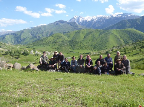
Team members
Karen Radner (project director – LMU Munich) (not in the field)
Janoscha F. Kreppner (project director – Münster University) (not in the field)
Andrea Squitieri (field director – LMU Munich)
Hero Salih Ahmed (representative of Sulaymaniyah Directorate of Antiquities)
Mark Altaweel (landscape archaeology – UCL London)
Silvia Amicone (pyrotechnology – Tübingen University)
Eileen Eckmeier (soil analysis – LMU Munich)
Jörg Fassbinder (geophysics – BLD/LMU Munich)
Cajetan Geiger (geology – Bochum University)
Jean-Jacques Herr (pottery – VEPMO-ArScAn UMR7041, LMU Munich)
Ibrahim Manla Issa (cook – Erbil)
Eimo Mustafa Manla Issa (assistant cook – Erbil)
Sophie Pietsch (assistant trench supervisor – FU Berlin)
Abubakir Qasim (representative of Raparin Directorate of Antiquities)
Jens Rohde (trench supervisor – LMU Munich)
Marion Scheiblecker (geophysics – LMU Munich)
Aziz Sharif (driver - Sulaymaniyah Directorate of Antiquities)
Three workmen from Nuraddin village
1. Introduction (Andrea Squitieri)
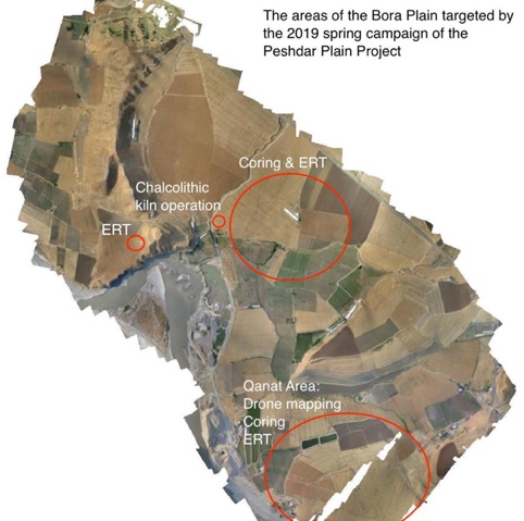
The Peshdar Plain Project 2019 spring campaign took place between April 19th and May 5th 2019, with three main goals (Fig.1):
1) Excavation of the Chalcolithic kiln found during the 2018 Autumn season;
2) Study of the landscape of the Bora Plain;
3) Sampling from ancient streets in the Lower Town of the Dinka Settlement Complex.
1) Excavation of the Chalcolithic kiln
During the 2018 Autumn campaign, a Chalcolithic kiln was partially exposed under the Iron Age structures of the operation DLT3 (UTM 512250; 3999220), located about 400 m west of Gird-i Bazar. The aim of this campaign was to expose as much as possible of the kiln structure, taking several samples for both pyrotechnic and archaeomagnetic analyses, and collect pottery and charcoals to better define the dating of the kiln. The kiln excavation was supervised by Jens Rohde with Sophie Pietsch acting as assistant. The sampling was carried out by Silvia Amicone and Jörg Fassbinder. Funds for the kiln excavation were made available by the Rust Family Foundation through a grant awarded to Andrea Squitieri and Mark Altaweel in March 2019.
2) Study of the landscape of the Bora Plain
The study aimed to investigate the following questions:
How was the qanat system organised?
The qanat system in the Bora Plain is partially visible through some openings located in the eastern part of the plain that connect to a subterranean channel. This system was used in antiquity and reused in modern time for irrigation. One of the objectives of the project was to understand how and when this system developed, and how it relates to the Dinka Settlement Complex. A combination of drone mapping (by Andrea Squitieri), coring (by Mark Altaweel & Eileen Eckmeier), and ERT (by Jörg Fassbinder & Marion Scheiblecker) was applied in order to understand the source and the extension of the qanats.
How old are the terraces of the Lower Zab that fringe the southern portion of the Lower Town of the Dinka Settlement Complex and how did they form?
To answer these questions, we continued the coring started in autumn 2018 in various spots of the plain, especially targeting the river terraces. The coring was supervised by Mark Altaweel and Eileen Eckmeier. The samples will be analysed by Eileen Eckmeier at the LMU.
How is the geology of the area surrounding the Dinka Settlement Complex characterised?
This question concerns the reconstruction and localisation of the sources of raw materials available to the inhabitants of the settlement. The geological mapping of the area, started in autumn 2018, was continued during this campaign in order to map potential sources for stones, as well as sources for clay suitable for pottery production. The geological mapping was carried out by Cajetan Geiger with the help of Silvia Amicone.
3) Sampling of the ancient streets of the Dinka Settlement Complex
The Lower Town of the Dinka Settlement Complex extends between Gird-i Bazar and Qalat-i Dinka. It was the focus of a magnetic survey in 2016, which revealed several archaeological structures including streets running among buildings (Fassbinder et al. 2017). Although the complete street pattern of the settlement is still unknown, enough was visible in the magnetogram to enable a street pattern analysis devised by Mark Altaweel and Andrea Squitieri in December 2018. This analysis has allowed us to highlight possible main streets, i.e. streets with heavier traffic, as opposed to secondary streets. In order to test the validity of this analysis, it was first necessary to determine the street level by carrying out some coring along the streets. Preliminary results are shown below, though a full analysis of the cores will be carried out in Munich by E. Eckmeier. The complete analysis of the cores should be able to distinguish between main and secondary roads based on the granulometry of the sediments at the street level (main roads should display a finer granulometry than secondary roads because they were more heavily trafficked). If this confirms the identification of the main streets, it would be possible to predict the location of public buildings (such as shops, or main temples) along these roads.
2. Excavation of the Chalcolithic Kiln (Jens Rohde)
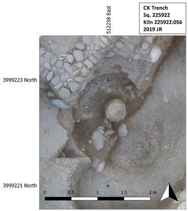
One of the results of the 2018 campaign in operation DLT3 was the discovery of a Chalcolithic kiln below the Iron Age settlement architecture. The 2019 spring campaign focused on the excavation of structure of this kiln. The structure is a double-chamber up-draught kiln, about one third of which is preserved. The upper part of the kiln was fully destroyed, though a few tumbled remains of it were found inside the kiln fill. Originally, the kiln consisted of two parts: the firing chamber, which was likely above ground, and the combustion chamber, which was dug into the ground from a floor or surface which is no longer preserved because it was destroyed by the Iron Age settlement architecture. Immediately below this architecture, the highest parts of the combustion chamber were observed (Fig. 2).
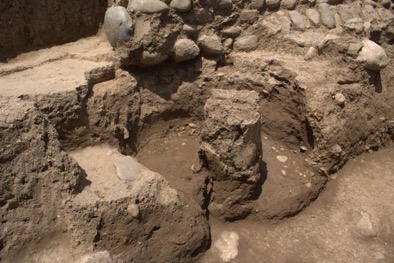
The combustion chamber reaches down to the natural pebble layer. Above this layer, there is an accumulation of a dark, yellowish-brown soil with some pebbles (Fig. 3).
The lining of the combustion chamber consists of heavily fired clay, with a green-greyish appearance. At the backside of the kiln, the soil was made red by heat. The lining leads down almost vertically, but does not extend to the floor as the lower part of the lining was poorly preserved. At the center, a central column is found, made of clayey material with a lining that is more light greyish than the outer lining.
The column is broken in the lower half and slightly pushed out of its original position because of destructive processes at the end of the kiln use. The remaining northwestern third of the kiln was filled with architectural elements of the kiln, along with some bones, sherds and flint. All baked architectural elements of different shapes were collected in several collections. Among the most striking fragments are the planoconvex elongated elements that are part of the supporting structure located between the edge of the kiln and the central column. There were also fragments with one flat side and a concave imprint on the backside, which probably helped to fix the planoconvex elements between the column and the outer edge. Some fragmented remains of holes could be part of the kiln floor. Several pieces of rather thick, but flattish elements probably belong to the outer construction of the firing chamber. Many fragments are quite small and require further investigation, which will be done by Sophie Pietsch. Though geographically far removed, a very close typological parallel is the kiln from Darre-ye Bolāghi, site 131 (Helwing and Seyedin 2010).
3. Pottery work (Jean-Jacques Herr)
Late Chalcolithic 1-2 pottery
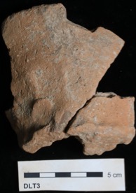
The excavation of the kiln has yielded 24 diagnostic sherds (367 g) and 83 non-diagnostic sherds (2273 g). The diagnostic sherds are consistent with a Late Chalcolithic 1-2 chronology. Fragments of flaring rim pots with faint red painting have been found along with sherds showing the typical chaff temper. One complete profile of a conical bowl with a flat base has also been found in the kiln fill. It shows marks of pinching and drawings on the base (Fig. 4).
4. Landscape study of the Bora Plain (Mark Altaweel)
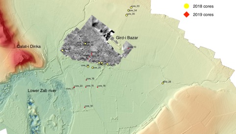
The April-May season in the spring of 2019 focused on several goals that included: determining the presence of a qanat south of the Dinka Settlement Complex, further determining the relationship of the lower terraces to the site, determining the possible extent of the site to the east, and determining if it is possible to sample from the street level of the site of the Dinka Settlement Complex. Figure 1 shows the areas worked in the last two seasons.
Determining the Qanat
The qanat southeast of the Dinka Settlement Complex had been known since the 2015 season. It has also been investigated using electrical resistivity tomography (ERT) in the 2016-2017 seasons. During those campaigns, some idea of the direction and location of the qanat was gained. However, we wanted to determine the depth of the qanat. Cores (21-25) were taken along two courses of the qanat(s). The cores were not conclusive in determining the depth of the qanat. This was because at about 2 meters we encountered large gravel layers that made further coring difficult in many of the sampled areas. This could be related to the construction of the qanat, as the ERT had shown the qanats were likely lined with stones (Fig. 5).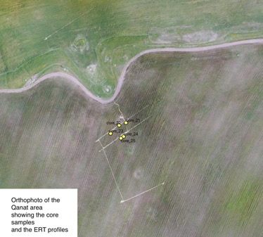
Coring along the Lower Terraces
We wanted to further delineate the lower terraces south and southwest of the Dinka Settlement Complex. These cores (26-28) continued to show, similar to the 2018 season, that the site did not extend to the south and southeast, suggesting that either it was eroded or perhaps the ancient Lower Zab extended into this area. Charcoal was found along with mainly alluvial sediments. The charcoal could possibly be of aid in dating the terraces (Fig. 6).
 Coring on the Eastern Dinka Settlement Complex
Near the chicken farm, and to the east, we cored (Cores 33-35) along the gravel road that leads to the chicken farm. There, we determined that it is possible that the site extended to this area and further investigation might be warranted. We could not core more than 2-3 metres in this area, as gravels and stones were encountered.
5. Geological survey of the Bora Plain and surroundings (Cajetan Geiger)
From April 20th to 30th a geological field survey was undertaken. The aim was to investigate some features mapped in the autumn campaign in October 2018 in further detail and to extend the mapped area for a broader understanding of the surrounding geology of the excavation sites. The Dinka-Conglomerate as well as the riverbed cobbles from Zab river were studied in detail in order to investigate the origin of the constituents. This is archaeologically interesting as both features could be potential sources of raw materials for stone tools and wall foundations. To understand the partially identical clasts a range of comparable samples was taken for further mineralogical analysis. We further began tracing the origin of these cobbles and pebbles. First attempts were made but further fieldwork will be necessary to really understand the connection between the sediments in the Bora-/Peshdar-plain and the surrounding hard rocks.
Several clay and stone samples were also taken around the archaeological sites for comparison with materials used in the excavated potteries. The petrographic analysis done so far has already provided intriguing hints, but more reference material was necessary.
6. Electrical Resistivity Survey (ERT) (Jörg Fassbinder & Marion Scheiblecker)
The Electrical Resistivity Tomography survey was conducted:
- On the western slope of Qalat-i Dinka, to investigate the possible fortification wall highlighted in the 2015 magnetic survey
- Across the Lower Town of the Dinka Settlement Complex, to get more information about the building foundations, the paleo-wadi crossing the settlement, and the limits of the settlement;
- In the Qanat area, to intercept underground channels.
In total, 19 ERT profiles were measured: 2 across a possible defence wall on the western slope of Qalat-i Dinka, 7 across the Dinka Lower Town; and 10 across possible Qanat systems (Fig. 7). Depending on the profile length, we adjusted the probe separation. These were 0.5, 0.75 or 1 meter. This allows a penetration depth of 7 to 10 meters. We show here just two profiles representing the different structures we prospected (see below). The measured data are plotted in the upper image, while the inverse model, featuring the different resistance values, is plotted in the bottom image. These results will be further processed in Munich to get better images and produce interpretations.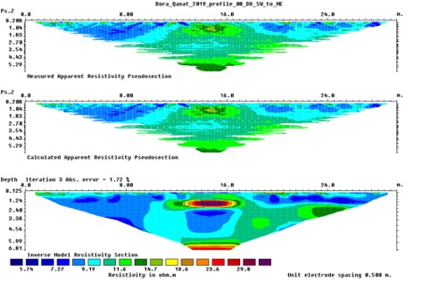
In the profile in the western slope of Qalat-i Dinka, features of different structures with different resistance can be identified. This is in correspondence with the 2015 magnetometer survey. For the cross-section of the Qanat (Fig. 7), an anomaly can be seen that can be interpreted as a channel. The raw data collected from these ERT profiles needs further processing and interpretation, which will be carried out in the Munich laboratory, to produce results which can be also compared with the magnetogram results already obtained in 2015.
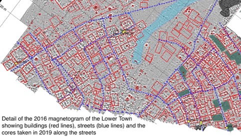
7. Sampling from ancient streets in the Lower Town of the Dinka Settlement Complex (Mark Altaweel)
Another goal of this campaign was to determine the street level of the Dinka Settlement Complex. The streets in question were identified in the magnetometry, which showed a clear linear street network in many areas of the site. We want to apply an experimental procedure which would sample sediments from the street levels so we can determine a better idea of ancient traffic patterns. Cores (29-32, 36-40) were taken that attempted to sample from different streets, which will be exported to Germany for analysis. Overall, it is likely that we did go through several streets in almost every sample taken. The levels of the streets likely varied between 0.5 cm to 1.5 meters in places. Samples included charcoal, pottery fragments, and sediments. Samples were taken along the cores for a granulometry analysis in order to determine which roads were more trafficked (Fig. 8).
8. General conclusions
The Peshdar Plain Project 2019 spring campaign accomplished all its objectives. The excavation of the Chalcolithic kiln was brought to completion thanks to funds from the Rust Family Foundation. The architecture of the kiln was clarified, and several samples for pyrotechnic, archaeomagnetic, radiocarbon, and pottery analyses have been collected. 3D models of the kiln are also available to reconstruct its structure and the excavation process.
The study of the Bora Plain landscape was continued with the collection of 20 core samples from the Lower Zab terraces to investigate their formation process. Methods such as drone mapping, ERT (Electrical Resistivity Tomography) and coring were applied to the investigation of the Qanat systems of the plain. A geological survey was conducted across the plain and its surroundings to detect possible sources for raw materials (stones and clay especially), and finally ERT and coring were carried out at some spots of the Dinka Settlement Complex to better understand its archaeology. Most of the results will be available once the data from these analyses and samples have been processed.
Reference this material
Andrea Squitieri, 'Preliminary report on the 2019 spring activities at the Dinka Settlement Complex and in the Bora Plain – 19th April – 4th May 2019', Ancient History Department, LMU Munich, 2019 [http://www.en.ag.geschichte.uni-muenchen.de/research/peshdar-plain-project/ppp2019spring/]