

Gird-i Rostam Excavations
A joint LMU-NYU project headed by D.T. Potts and Karen Radner
Introduction
Gird-i Rostam (UTM 582780 E, 3956890 N) is a relatively small (1.5-2 ha), but tall (15 m high), multi-period settlement mound in the easternmost part of the Kurdistan Region of Iraq, directly on the border with Iran (Fig. 1).
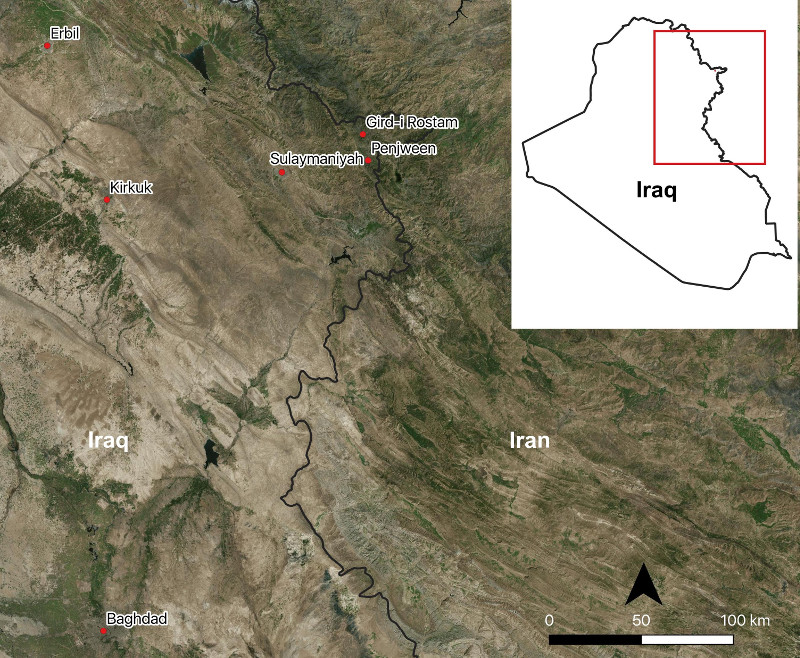
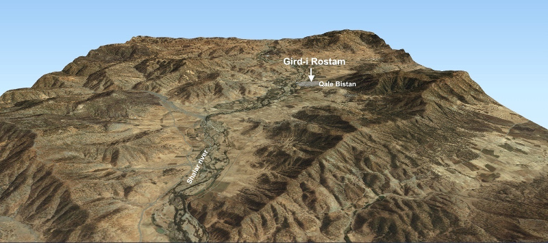
It lies in a high plain called Dasht-i Bazargan, at an elevation of approximately 1200 m above sea level, close to the Shiller (also spelled Shalar) river, a tributary of the Lesser Zab, which bisects the plain in an east-to-west direction. The main centre of the region is Penjween, located about 14 km south of Gird-i Rostam. Claudius Rich visited the nearby hilltop site of Qale Bistan, from which he looked down on ‘Rustum’s Mount’ in 1820, but it was not until 1959 that Kamal Mansur and Tariq Madhloom (Directorate of Antiquities, Baghdad) visited the site and noted the presence of sherds which they dated to the Uruk and Old Babylonian/Isin-Larsa periods.
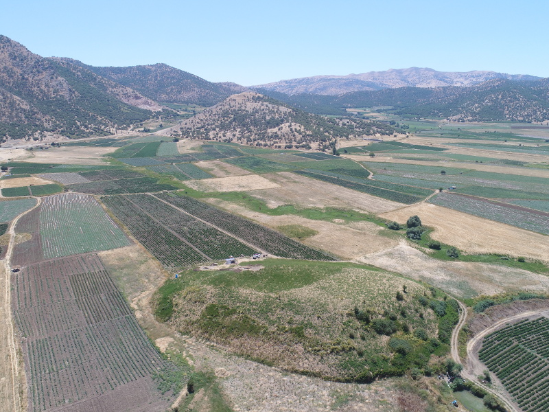
Despite the extensive archaeological work carried out in the Sulaymaniyah region during the past two decades, the area of Penjween remained largely unexplored, remaining an archaeological terra incognita. Gird-i Rostam was brought to the attention of the Directorate of Antiquities in the Governate of Sulaimaniyah in 2016, when Kamal Rasheed, Director of the Board of Antiquities and Heritage in Sulaymaniyah, suggested to Prof. Karen Radner (LMU, Munich) that she consider investigating it. Subsequently, two visits were made to the site in May and August 2017, by Prof. Karen Radner, Prof. D.T. Potts (Institute for the Study of the Ancient World, New York University; hereafter NYU), Dr. Andrea Squitieri (LMU, Munich) and Mr. Amanj Ameen, and the site and its environs were mapped by drone (Figs. 2, 3, 4). Thereafter, the idea arose that NYU and LMU should join forces to conduct excavations at the site, and an initial season of excavation at Gird-i Rostam was conducted from June 28th to July 24th, 2018, under the auspices of the Directorate of Antiquities of Sulaymaniyah.
Main goals
The Gird-i Rostam excavations have four main goals:
- A detailed reconstruction of ceramic technology at the site through time, for the purpose of comparison with neighboring regions (Assyria, Babylonia, Media, Elam).
- The refinement of the chronology of the Late Chalcolithic in northern Mesopotamia — The recent work on the Late Chalcolithic chronology of northern Mesopotamia, based on both older excavations (e.g. Tepe Gawra, Yarim Tepe, Telul eth-Thalathat, Tell Brak) and newer ones (e.g. Helawa, Tell Nader, Surezha) highlights the imprecise nature of the existing chronology, with dates for LC1-2 deposits floating between c. 4800 BC and 3800 BC. The excavation of the LC deposits at Gird-i Rostam promises to make a real contribution to the determination of the Late Chalcolithic chronology of northern Mesopotamia in general and eastern Kurdistan in particular.
- The Assyrian impact on eastern Kurdistan — Located in an agriculturally rich zone, in the piedmont of the Zagros mountains, Gird-i Rostam offers an excellent opportunity to investigate the strategies of the Neo-Assyrian Empire (9th-7th centuries BC) in the strategically important highlands east of this state’s core region on the Tigris. Despite a wealth of epigraphic evidence attesting to the Assyrian conquest of the easternmost part of the Kurdistan Region of Iraq (principally the royal Assyrian inscriptions with their year-by-year
accounts of military interventions), the archaeological signature of that impact is poorly known. - Gird-i Rostam, the Sasanian empire and the Nestorian ecclesiastical province of Beth Garmaye — Northern Mesopotamia was part of the Sasanian empire and home to a large Nestorian Christian population prior to the arrival of Islam. However, the sources on the ecclesiastical province of Beth Garmaye, with its center at modern Kirkuk, are silent on the area of Gird-i Rostam. Thus, continued exposure of the latest occupation at the site will shed important light on the very poorly documented archaeology of the late pre-Islamic population, both Christian and pagan, of northern Mesopotamia.
Summary of the 2018 excavation results
The 2018 team consisted of Mr. Amanj Ameen and Mrs. Perween Yawer, representatives of Directorate of Antiquities (Sulaymaniyah); Prof. D.T. Potts (NYU, excavation co-director); Mr. Christoph Forster (www.datalino.de, Berlin, database); Dr. Andrea Squitieri (LMU, Munich, database, and small finds), Mr. Jens Rohde (LMU, Munich, trench supervisor) and Dr. Jean-Jacques Herr (LMU, Munich, pottery and trench supervisor); Hero Salih, Directorate of Antiquities (Sulaymaniyah, pottery processing); Mrs. Hildreth Potts (New York, illustrator); Aziz Sharif (diver), Muhammad Aziz (pottery washing), Ibrahim Issa (cook), and Hamrin Mala Issa (assistant cook).
Details of the results of the 2018 excavation season have been published in:
Potts, D. T., Radner, K., Squitieri, Andrea, Ameen, A., Rohde, J., Yawar, P., Herr, Jean-Jacques, Salih, H., Petchey, F., Hogg, A., Gratuze, B., Raheem, K.R. and Potts, H.B.: Gird-i Rostam 2018: Preliminary Report on the First Season of Excavations by the Joint Kurdish-German-American Team. Journal of the Ancient Near Eastern Society "Ex Oriente Lux", Vol. 47: pp. 91-127. Available for download.
Below is a summary of these results:
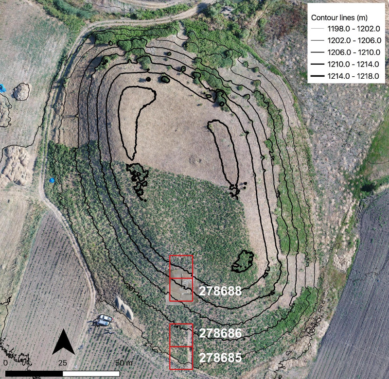
- A wealth of Late Chalcolithic pottery was collected in square 278685. A charcoal sample from the lowest layers has yielded the date 4446-4336 calBC (95% probability), which collocates this occupation firmly in the LC-1 horizon.
- Large quantities of Sasanian pottery came from squares 278685 (above the Late Chalcolithic layers), 278686 and 278688. Interestingly, two sherds show a decoration made of impressed crosses in a circular field (Fig. 5).
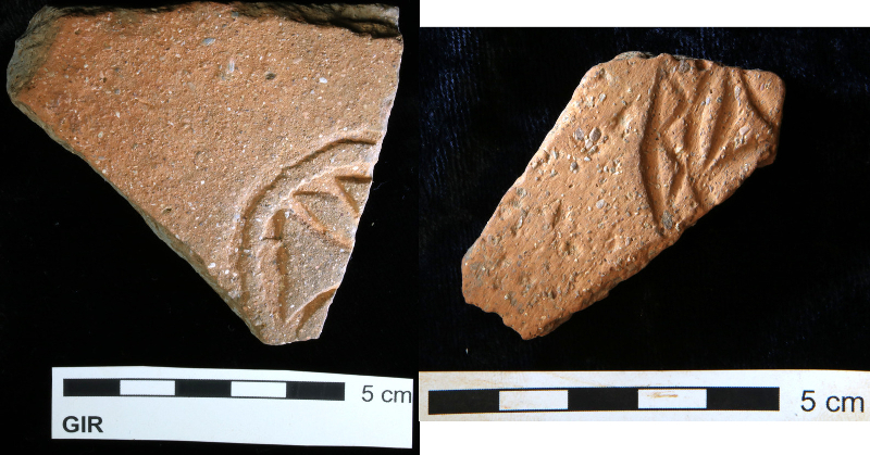 Fig. 5: Two Sasanian sherds with cross stamped decoration.
 - Up the slope, in square 278688, in a 2 x 2 m sounding, a stone wall made of large, flattish schist was intercepted. A radiocarbon date was obtained from a charcoal piece from a fill next to the wall (but not associated with any surface), which was dated to 2295-2147 calBC (95% probability).
The most important find from this sounding was an inscribed pottery sherd of a carinated bowl that came from a fill adjacent to the wall. The sherd (GIR 278688:010:005; Fig. 6) bears a fragmentary cuneiform inscription in Akkadian language and Neo-Assyrian script:
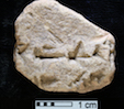
(1) [… (DUG.)G..ZI GEŠT]IN an-nu-u š[á ... ] (2) [...] dIM [...]
“[...] this wi[ne drinking bowl] which [...] Adad [...]”
Such drinking bowls were common during the later 8th and 7th centuries BC throughout the Assyrian Empire and were reserved for wine, then a high-status drink. In particular, these vessels were used to drink wine during ceremonial occasions, such as when banqueting as part of the conclusion of a treaty with the king of Assyria, the imperial power of that age. The inscriptions they bear, when inscribed, often mention their owners by name and / or title, as may be the case here. Many Assyrian-period names contain the divine element Adad, the name of the weather god, e.g. personal names such as Rim- Adad, (‘Beloved by the god Adad’) or Adad-remanni (‘O Adad, have mercy on me’), or toponyms such as Dur-Adad-remanni “Fortress of Adad-remanni”; the latter is a place located in the region of Gird-I Rostam and it is therefore a distinct possibility that it is mentioned in this inscription. A study by Karen Radner is forthcoming.
For a study, see Karen Radner, “A bit of Assyrian imperial culture: the fragment of an inscribed pottery bowl from Gird-e Rūstam (Iraqi Kurdistan).” Altorientalische Forschungen 48/1 (2021) 118-124.
Summary of the 2019 excavation results
The 2019 excavations took place from 2-30 July 2019 thanks to the generous and continuous support of: Kamal Rasheed, Director of the Board of Antiquities and Heritage in Sulaymaniyah; and Zana Abdulkkarim, Amanj Ameen and Mrs. Parween Yawar, representatives of the Directorate of Sulaymaniyah. Funding was provided by the NYU-LMU partnership scheme for supporting joint projects, the Rust Family Foundation, and the Institute for the Study of the Ancient World (NYU). The team was composed of: Zana Abdulkkarim and Parween Yawar (representatives), Prof. Daniel T. Potts (NYU, co-director), Prof. Dr. Karen Radner (LMU, co-director), Dr. Andrea Squitieri (LMU, Munich, database and small finds), Jens Rohde (LMU, Munich, trench supervisor), Alessio Palmisano (UCL, trench supervisor), Dr. Jean-Jacques Herr (LMU, Munich, pottery and trench supervisor); Dr. Abdullah Bakr Othmann (Salahaddin University Erbil, pottery processing); Cajetan Geiger (LMU, geology), Hildreth Potts (New York, illustrator); Aziz Sharif (diver), Ibrahim Issa (cook), and Eimo Mustafa Mainla (assistant cook).
The main results of the 2019 season are:
- In square 278685, the virgin soil was reached under the Late Chalcolithic layers.
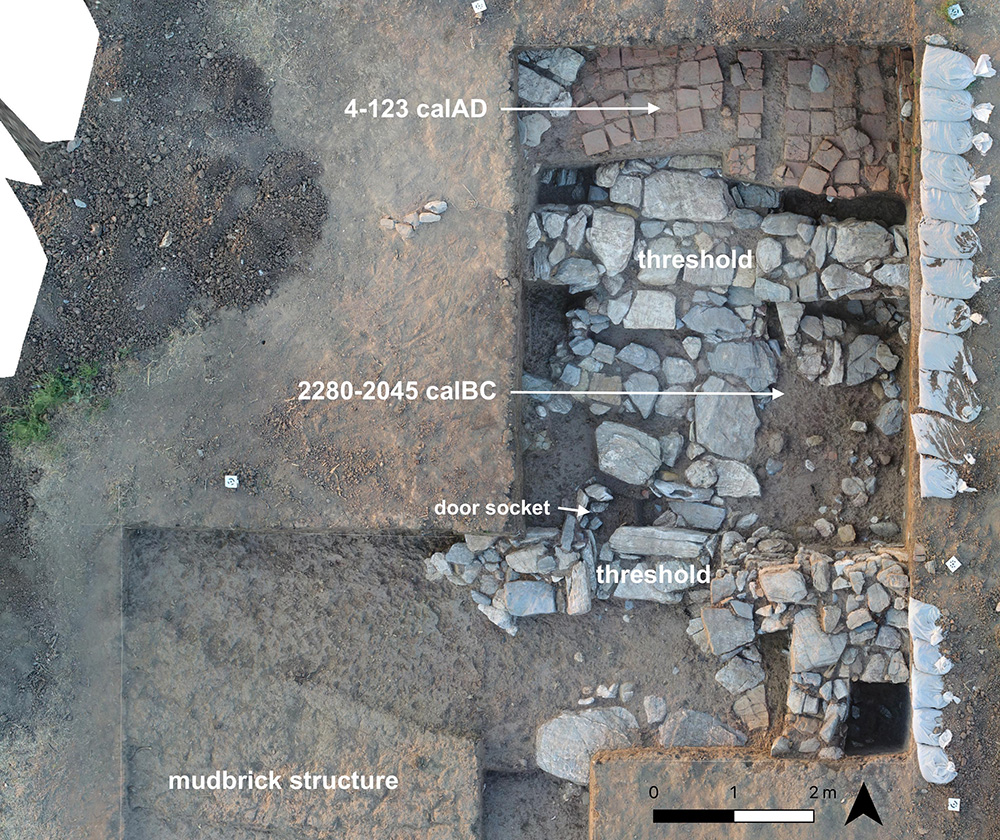
- In square 278688, the 2018 sounding was enlarged, revealing a large structure about 7 x 6 m made of local stone (Fig. 7). This structure is composed of three units connected by two wide passages, which leads to the interpretation of this structure as a monumental gateway. A charcoal sample from the floor was radiocarbon dated to 2280-2045 calBC. This structure was in part sealed by a later brick-built floor, on which another charcoal sample yielded the radiocarbon date 4-123 calAD.
Summary of the 2022 excavation results
After a Covid-19-enforced interruption, the third season of excavations took place from 25 June-17 July 2022, with the generous and continuous support of Kamal Rasheed, head of the Directorate of Antiquities and Heritage in Sulaymaniyah and funding provided by the Gerda Henkel Foundation and the Institute for the Study of the Ancient World (New York University).
The team consisted of: Dan Potts and Karen Radner as co-directors, Awaz Jehad and Parween Yawar as representatives of the Directorate of Antiquities and Heritage in Sulaymaniyah, Amanj Ameen, Cajetan Geiger, Jean-Jacques Herr, Jens Rohde, Andrea Squitieri and Hildreth Potts as field team, Aziz Sharif (driver), Ibrahim Issa (cook), and Eimo Mustafa Mainla (assistant cook).
Excavations were focused on square 278688 where monumental fortifications with a north-south-oriented gateway had been partially uncovered in 2019. We excavated parts of a massive wall with buttresses. From the south and therefore outside, an entrance paved with large stone slabs leads into the gate chamber (Space 3, excavated already in 2019) while from the north and therefore inside the settlement, steps lead down from an area paved with large stones that continues beyond the limits of the trench into that gate chamber. To the east, Space 7 was excavated down to a stone-paved floor, with the fill yielding Iron Age pottery sherds. The pottery collected here and elsewhere can, for the most part, be assigned to the Iron Age based on parallels from the Dinka Settlement Complex (Lower Town) and Hasanlu. While it, therefore, seems clear that the fortifications were in use during the Iron Age, the radiocarbon date from the 2019 excavations suggests that they were constructed already much earlier and prompt one to speculate on the geopolitical significance of the site throughout history.
Traces of later occupation were detected in Space 1 and 6. The pottery from these contexts can be assigned to the Sasanian period, although a Parthian date cannot be excluded for some sherds. Space 1 is paved with square bricks, which had been uncovered already in 2019. To the west, a large drain was excavated, about 3 m long and 1.5 m wide, which damaged the Iron Age deposits on the western side of Space 3. In Space 6, a baked brick installation, interpreted as a cooking installation, was unearthed.
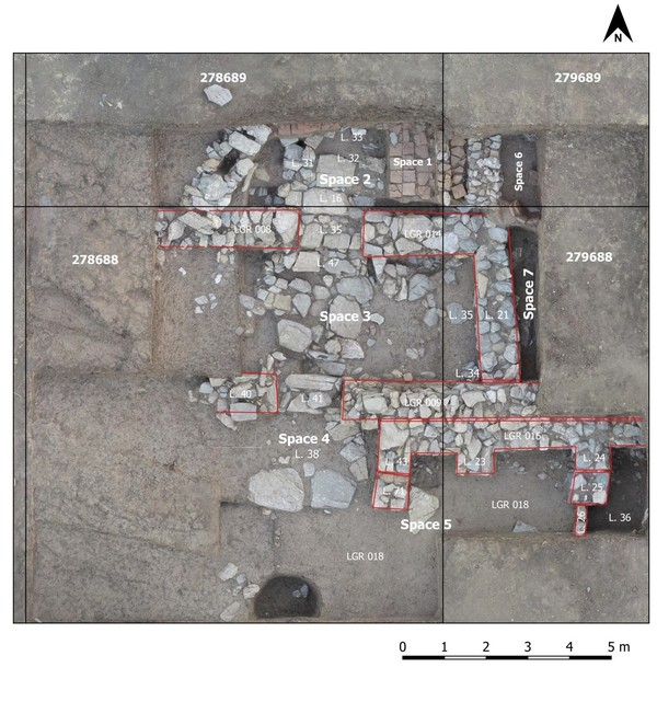
Orthophoto of the excavated area in 2022. By Jens Rhode.
We thank our sponsors: the Gerda Henkel Foundation (64_V_17; 05_V_20), the Rust Family Foundation, LMU Munich and NYU, in particular through the LMU-NYU Academic Partnership programme.
